1. General Description
The Port of Pecém is an artificial external port for mixed use and a property of the State Government of Ceará, whose port authority is:
Companhia de Desenvolvimento do Complexo Industrial e Portuário do Pecém – CIPP S/A
Esplanada do Pecém, s/n° – Distrito do Pecém São Gonçalo do Amarante – Ceará – CEP: 62.674- 000,
municipality of São Gonçalo do Amarante, west coast of Ceará, 56 km away from the city of Fortaleza via highway.
Telephone: (55 85) 3372 1500 (24 hour assistance)
E mail: cearaportos@cearaportos.ce.gov.br
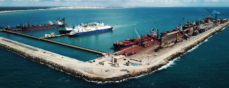
2. The Port of Pecém
The Port of Pecém is essentially made up of an L-shaped protection jetty – Berma style, paralleled to quay 868 m away and another paralleled to the beach 2000 m away from coastline with tree berthing facilities, two in the shape of a pier, with two berths each and one with continuous berth, being pier 1 for commercial operations with no solid cargo bulk, pier 2 for LNG transshipment between vessels and pier 3 for commercial operations with general cargo and solid bulk.
The ocean floor topography in the Port of Pecém region is dominated by rock occurrence along the surf zone. By Ponta de Pecém there are significant extensive areas covered by these outcrops.
Results from the seismic survey indicate volcanic rocks forming the bedrock covered by sand sediments and sludge. The thickness of the sediment layer varies inconstantly from 0 to 18 m in the shore / offshore directions and on the portion paralleled to the coastline. This is caused mostly by the fluctuation of the rocky base’s bottom layer.
Sand layer thickness is not much at depths lower than 10 m.
At depths between 10 m and 16 m, volcanic rocks dominate. At depths lower than 16 m, the ocean floor surface is covered mostly by the sand sediments.
The port is operative 24 hours a day, during all the year.
3. Location
a. Coordinates
Geographic position: latitude 03°30’00” S and longitude 39°50’00” W
b. Anchorage Areas
Designated or Recommended Anchorage Areas
| Number | Location | Radius | Depth |
|---|---|---|---|
| 01 | 03º28’50 S 038º49’50 W | 0.3 nautic miles | 15.5 |
| 02 | 03º29’50 S 038º46’50 W | 0.5 nautic miles | 15.5 |
c. Navigation Help
No beacon-marked access channel. Berthing facilities are directly linked to the deep sea.
d. Port Limits
The authorized limits at the Port of Pecém are 200 meters from port structures (Piers, Bridge and Breakwater) all the way up to the buoys which limit the maneuvering area, as shown in the picture below:
4. Port Control or VTS (Vessel Traffic Service)
The Maritime Authority at the Port of Pecém is the State of Ceará Port Authorithy, from the Navy Ministry.
Capitania dos Portos – Marine Authority
Av. Vicente de Castro, 4917 – Mucuripe
Fortaleza – CE
CEP: 60180-410
Fax: +55 (85) 3219 2802
e-mail: secom@cpce.mar.mil.br
The use of the anchorage area and access to the port by the vessels shall be authorized by CEARÁPORTOS, in accordance with previous authorization by the Maritime, Customs, Sanitary Authorities and the Maritime Police.
With the exception of the “arribada” (where a vessel docks into any national port for purposes other than loading/discharging, such as in the cases of bunker, fix and repair of the vessel), the shipowner, the waterborne carrier or agent, depending on the case, must request the previous authorization by providing the following information in no less than 24 (twenty-four) hours prior to arrival:
• Name of the Ship;
• Flag under which it sails;
• Navigation type and purpose;
• Last port of clearance and next port;
• Name and address from the person in charge of the vessel and the payment of port taxes;
• Vessel’s characteristics: (1) total length and beam; (2) dead weight tonnage, gross tonnage and net tonnage; (3) maximum draft, arrival draft and expected departure draft;
• Type of operation;
• Loading or discharging cargo bill or tentative detailed information on the cargo. This information is by EDI to Customs System and the Single Window system;
• Number of passengers disembarking or boarding;
• Expected arrival and departure dates;
• Any irregularity or abnormality which might affect navigation safety or harm the effective use of the port facilities;
• Indicate any need for the use of equipments and services, and log;
• Expected time for the handling and organization of cargo;
• Miscellaneous services to be used.
• In the case of vessels carrying hazardous cargo, the shipowner, the waterborne carrier or agent must, in addition to the information above, provide the following specific data:
• Name of product, in accordance with the classifications in the Code of the INTERNATIONAL MARITIME ORGANIZATION – IMO, the United Nations Organization – U.N.; indicate flash point, where applicable;
• The quantity of hazardous cargo on board, identifying both the cargo which shall be dispatched at the Terminal and the cargo which shall remain on board, indicating its exact location on the vessel.
• The status of the hazardous cargo and the possibility of causing accidents;
• Information on any insurance certificate the vessel may hold for the transportation of the hazardous cargo.
PROCEDURES
a. Arrival
i. The Terminal reserves itself the right to refuse the berthing or operation of any vessel considered to be inadequate or which does not comply with safety or mooring conditions, or due to any other circumstances that might cause risks to the Terminal, including its personnel, equipments and the environment.
ii. Vessels heading to the Pecém terminal must inform their estimated time of arrival (ETA) 72, 48, 24 and 4 hours in advance, directly to the respective agent and to the operations department via e-mail, telex or telephone. Change or confirmation of the vessel’s arrival time must be informed at least 12 hours in advance. The ETA must always be informed using the UTC time.
iii. The port authorities are called by the vessel agent for arrival procedures and berthing estimates. Normally, the visit takes place after berthing.
5. Pilotage
Pilotage is mandatory for all vessels heading to the Port of Pecém, inside or outside port area. Pilots can be requested by the vessel representative 24 hours prior to arrival. They can also be requested through channel 13 or 16 on VHF radio telephone.
Pilots boarding and disembarking station is situated at:
>LAT = 03º 29’ 0” S and LONG = 038º 48’ 4” W.
Vessels must be sufficiently ballasted and properly equipped in terms of mooring and respective accessories.
Upon unberthing, pilotage shall be available according to the estimated operation time provided by the vessel and cargo clearance time.
The Master is the sole responsible for the maneuvers, therefore he shall provide the pilot with thorough information about any peculiarity, specific conditions or existing difficulties, such as defective machinery or boilers, damaged navigation devices or mooring or any other element which might cause damage concerning the vessel’s mooring, unmooring, loading and discharging.
The pilotage organizations operating at the Port of Pecém may be freely chosen by user. They are:
a) Ceará Marine Pilots – Pilotage Company from the State of Ceará Ltd, located on Rua Osvaldo Cruz, nº 01, salas 1307/1308, Meireles, Fortaleza-CE, CEP 60125-150, telephone/fax (85) 3242-4638 and VHF-FM Station 16, operating 24 hours every day. It works as the Pilotage Representative Entity, as stated in the item 0119 b) of NORMAM-12/DPC; and
b) Ceará State Pilots – Pilotage Company from the State of Ceará Ltd, located on Avenida Monsenhor Tabosa, 111, salas 39/41, Praia de Iracema, Fortaleza-CE, CEP 60165-010, telephone/fax (85) 3219-3849.
6. Navigation Risks
The main obstacles to navigation are the fishing boats, such as small wooden sailboats and canoes nearby the port.

7. General Restrictions
There are no restrictions in vessel maneuvering: ships may berth and unberth in any tide, unless there are specific conditions, such as lack of light beacons or in the case of recurring events, natural or not, or other joint decisions between the pilots and the companies involved, which might impose time restrictions.
8. Maneuvering Area
There is a maneuvering basin 310 meters away where ships up to 300 m length can maneuver, between Pier 02 and Pier 03 (the NW arm of the breakwater). For ships bigger than 300 m length, maneuvers shall take place with tug support and outside berthing area.
9. Berthing Support
For berthing and unberthing procedures, the Port of Pecém relies on its own workforce and contractors.
10. Bathymetric Survey
The Basin of Ceará is located on the continental platform of the Brazilian equatorial margin, comprising an area of approximately 34.000 km2. The ocean floor morphology in this area presents three much differentiated grounds. The first, located on the inner platform at a depth of 30 m, presents a surface leveled by sedimentary processes, where wavy patterns of about 20 cm height can be observed.
On the second ground, between 30 m and 50 m depth, one can observe the presence of a topographic gradient which varies from smooth to abrupt. The ridge starts showing irregularities, seen as erosive remnants, and beds of coralline algae; it can also alternate in depressive areas of very smooth ridges. The third identified ground goes all the way down to 70 m depth and has a topographic gradient more abrupt with the presence of beds of calcareous algae.
11. Dimensions Of Vessels
| Pier | Berth | Death Weight | Length [m] | Bean [m] |
|---|---|---|---|---|
| 1 | 1 | 75,000 t | 280 | 37.50 |
| 2 | 125,000 t | 300 | 47.00 | |
| 2 | 3 | 100,000 t | 290 | 42.00 |
| 4 | 175,000 t | 310 | 52.00 | |
| 3 | 5 | 140,000 t | 330* | 60.00 |
| 6 | 140,000 t | 330* | 60.00 |
• the pier 3 is continuous and this length is due to two vessel using on same time
12. Weather Conditions
a. Predominant Winds
Strong winds are very common in the region and may prevent berthing maneuvers as well as halt the operations. The predominant winds are shown on the table below:
| Direction | Frequency | Average Speed |
|---|---|---|
| SE / NO | 70% | 15 Km/h |
With winds stronger than 30 knots, direction 67 – 112 degT, with wave height 2,4m and period Tp 15s, vessel operations must be interrupted and the arms must be disconnected.
With winds stronger than 35 knots, direction 67 – 112 degT, with wave height 2,4m and period Tp 23s, vessel must leave the pier.
b. Waves
The directional wave measurer in Pecém lies at latitude 03° 29’ 31” and longitude 38° 59’ 03”.
Waves above 3.00 m have frequency of 11.23%. Above 4.00 m, 0.22%, being the highest wave of the 4.6 m and 4.7 m class, happening twice in the period as of 13/03/97 through 23/01/99.
The most frequent Significant Wave height (Hs) varies from 1.30 m to 1.40 m, with an 11.84% frequency. The occurrence of Hs between 0.90 m and 2.10 m is of 96.32%. The maximum significant wave class varies from 2.4 m to 2.5 m with three occurrences in the period as of 13/03/97 through 23/01/99.
In terms of direction, there are two dominant groups:
>90° D <_ 120° with a 66.74% frequency;
>30° D <60° with a 21.19% frequency.
c. Rain and Humidity
Rainfall varies, with a monthly average of 13.4 mm (in November) to 336.3 mm (in March), with air humidity varying between 70% and 85%.
d. Atmospheric Pressure
>Minimum: 1,0074 bar;
>Medium: 1,0087 bar;
>Maximum: 1,0100 bar.
e. Visibility
Usually it varies between good and excellent. It might be reduced during rain period. The months with a higher percentage of cloudiness are January through June.
f. Tidal Currents
Tidal current has the speed of 1 knot in the SE direction.
The current along the internal and external berths is weak due to the NW arm protection.
g. Tide
>Average Level: 1.42 m;
>High Water Springs Average Amplitude: 2.36 m;
>Mean High Water Springs: 2.70 m;
>Mean High Water Neaps: 2.08 m;
>Maximum Amplitude: 3.01 m.
h. Measuring
The Terminal has up-to-the-minute information on wind and current intensity and direction. Whenever the vessels approach the port in order to berth, this information can be made available through VHF radio to the vessel by the Terminal operator.
13. Management and Control
The terminal has an operation control center and electronic supervision, totally automated, by which all terminal operations can be monitored 24 hours a day.
14. Major Risks
The communication between vessel and terminal is instantaneous and made through a VHF/UHF radio, amongst other means. In the case of abnormalities, any of the parties, terminal or ship, may execute or request the operation’s immediate shutdown. In the event of leakage, pollution, fire, pressure surge, product contamination, tension oscillation from mooring lines and/or storms and lightning, the terminal or the ship must interrupt the operations immediately, isolate the area, execute contingency plan (where applicable) and initiate the event mitigation.
15. Berthing
a. Ship/terminal access
The piers at the Terminal have telescope ladders for easy access to the moored ships.
Crewmembers who disembark to use the Terminal’s installation, besides following all the procedures of the ISPS Code, must wear closed shoes, long pants and sleeved shirts and may circulate only in the demarcated area. The gangway on the side of the ship opposite to the mooring side must always be kept on deck while the ship remains moored, for the safety of the Terminal and the ship. That gangway may only be used in case of emergency.
b. Prior communication for start of mooring
To optimize the process of tending ships, including allocation of the Nautical Adviser and other measures, the ship must contact the Terminal via VHF channel 16 as soon as it starts maneuvering for mooring. The Terminal recommends that maneuvers for mooring at the jetty be started at least 30
c. Unberthing and Leaving Port
The pilot usually disembarks at the same boarding location stated in sub-item 5, where a pilotage boat from the Port will be awaiting.
16. ISPS CODE Compliance
The Terminal of Pecém has implemented entrepreneurial safety measures applicable to ships and port facilities, in compliance with the International Maritime Organization – IMO, by adopting the ISPS Code – International Ship and Port Facility.
These preventive measures can be put into action, where applicable, by the Ship through the Port Facility Security Officer (PFSO) or via VHF radio, on channels 16, 09 or 11.
The Terminal of Pecém operates normally at the security level 01. For further details, the Port Facility Security Officer (PFSO) must be contacted through the chosen agent.
CONTACTS
| Organization | Contact | Telephone (55 85) |
Fax (55 85) |
VHF/UHF Channels Call |
|
|---|---|---|---|---|---|
| Port Authorithy | Captain | 3219-7555 | 3219-7555 | secom@cpce.mar.mil.br | 16 |
| Port Control | Supervisor | 3219-7555 | |||
| Pilots | |||||
| Ceara Marine Pilots | Dispatcher | 3242-4638 | 3242-4638 | ||
| Ceara State Pilots | Dispatcher | 3242-4638 | 3242-4638 | 16 | |
| Tugboats | |||||
| Amarena | Amarena | 3219-6759 | 3219-3810 | brasimar@brasimarservicos.com.br | 16 |
| Juan Pablo | Juan Pablo | 4005-6151 | 4005-6161 | jdg@wilsonsons.com.br | 16 |
Naval repairs, garbage disposal, divers services can be obtained through the Agency
C – Port of Pecém’s basic information
Start of operations: November 2001
Administration: Companhia de Desenvolvimento do Complexo Industrial e Portuário do Pecém – CIPP S/A
Address: Esplanada do Pecém, s/ nº – Distrito do Pecém
City, State, ZIP Code: CEP 62674-000 – São Gonçalo do Amarante – CE
Customer Service: (55 85) 3372 1500
Website: www.cearaportos.ce.gov.br
E-mail: cearaportos@cearaportos.ce.gov.br
Coordinates: Lat 3º30’00”S Long 39º50’00”W
PORT ACCESS
Highway: BR-222 / BR-116 / CE-422
Railway: Companhia Ferroviária do Nordeste – CFN
Maritime: Does not exist
ACCESS CHANNEL
Length: Not applicable
Width: Not applicable
Maximum Depth: 18 m
PORT DIMENSIONS
Storage Area: 380.000 m2
Quay Length: 2,100 m
Number of Berth: 3
Significant wave height (Hs)
